

|
Virtual Tree Inventory
|
Can Street-level Imagery Help Assess Tree Damage from August 2020 Derecho Storm?LUFA Project Personnel: Annalise Nordgren, Camila Cortez, Elene Drosos, Jess Vogt
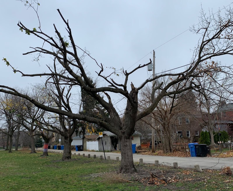
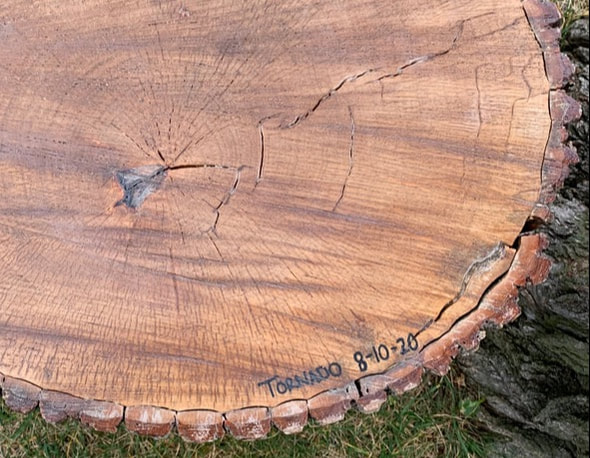
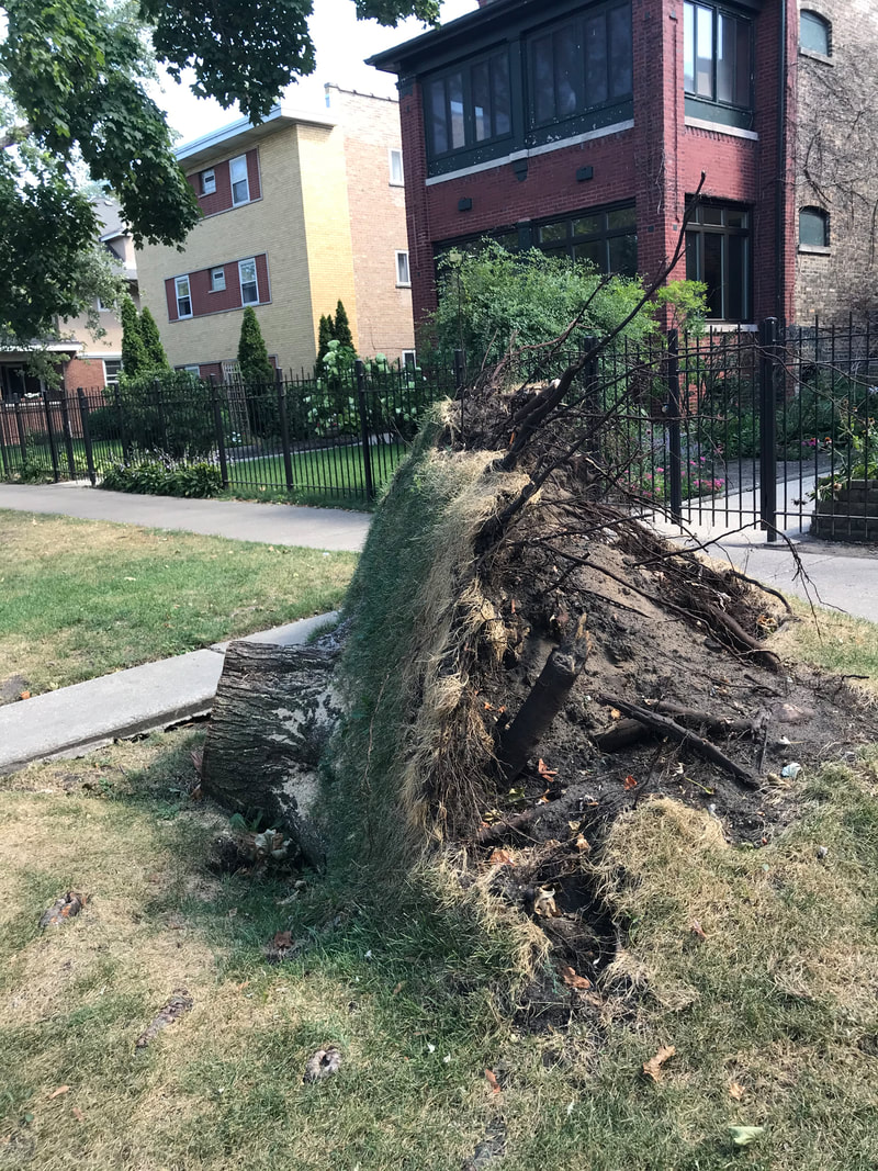
Collaborators: Jake Miesbauer (The Morton Arboretum), Adam Berland (Ball State University) On August 10th, 2020, a Derecho storm swept through Chicago, causing a plethora of damage: an estimated 12,000 urban trees were lost and far more injured. Inspired by the storm damage visible on trees in her neighborhood, LUFA research assistant Annalise Nordgren came up with an idea of investigating the extent to which Google Street View might be usable to help communities assess storm damage and damage potential. Although there is no way of knowing with 100% certainty whether a tree will be able to withstand the force of strong winds or storms, there are known structural and biological defects in trees that could indicate a higher chance of a tree being damaged or windthrown. This project will use two types of inventories -- an on-the-ground field inventory of selected transects (streets) in the Rogers Park neighborhood and nearby areas on the north side of Chicago, and a Google Street View inventory of the same transects -- in order to understand whether trees damaged in the storm displayed obvious structural defects. Through the two-part inventory, we are collecting data on tree form, size, species, growing conditions and any apparent defects. We hope this research will help promote the use of GSV as a survey tool to identify urban trees that are in great need of attention.
|
Some examples of storm damage from the August 2020 Derecho, in Rogers Park, Chicago, IL. Photos by Annalise Nordgren.
|

Can Field Crews Telecommute? 2017 Dolton, IL, street tree inventory
|
LUFA Project Personnel: Jess Vogt, Alli Preble, Kaitlyn Pike
Collaborators: Adam Berland (principal investigator for this project, Ball State University), Lara Roman (U.S. Forest Service, Philadelphia Field Station), Jake Miesbauer, Lydia Scott, Chuck Cannon, Lindsay Darling (all with The Morton Arboretum) Can Google Street View technology be used to inventory street trees? How cost- and time-effective is Google Street View compared to standard on-the-ground tree inventory methods? During Summer 2017, a LUFA field crew collaborating with Ball State University and the U.S. Forest Service conducted research to answer these questions.
Street tree inventories are critical to municipal forestmanagement, but many communities cannot afford to conduct field-based inventories. It is possible to characterize street trees by manually interpreting images in Google Street View, which offers a free and user-friendly platform for accessing ground-level photographs taken along roads throughout the USA. Adam Berland (Principal Investigator on this research, at Ball State |
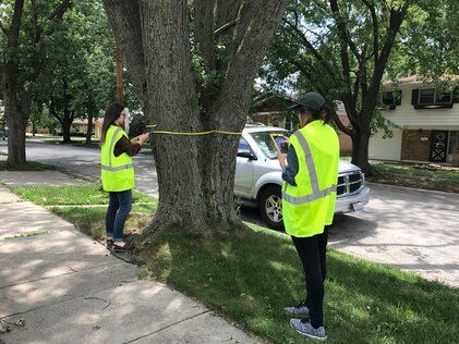
Alli Preble and Kaitlyn Pike survey a large silver maple tree in Dolton, IL, in 2017 for the "Can Field Crews Telecommute?" project.
|
University) previously conducted a proof-of-concept study demonstrating that a ‘virtual survey’ in Street View can produce reasonably accurate data about street tree variables relevant to municipal management such as tree abundance, genus, and size class. However, that virtual survey was conducted by a single analyst with expertise in urban forest inventories, so we do not know how well this approach can be carried out by less experienced municipal staff or citizen scientists.
This project will build upon existing research to improve our understanding of the possibilities and limitations of conducting virtual street tree surveys in Google Street View. We will enlist analysts ranging from experts to novices to conduct virtual surveys to record basic tree attributes, and their performance will be evaluated against field data from the same set of streets. We are primarily interested in determining,
This project will build upon existing research to improve our understanding of the possibilities and limitations of conducting virtual street tree surveys in Google Street View. We will enlist analysts ranging from experts to novices to conduct virtual surveys to record basic tree attributes, and their performance will be evaluated against field data from the same set of streets. We are primarily interested in determining,
- What overall level of data quality can be generated using a virtual survey approach as compared to field surveys; and,
- How data quality varies according to the analyst’s level of expertise, and whether citizen scientists can generate reliable data for management purposes.
Products, Presentations, & Publications
Nordgren A (2021) Analyzing tree damage from August 2020 derecho storm in Chicago. DePaul University 18th Annual Undergraduate Research Showcase, April 16, 2021, DePaul University, Chicago, Illinois. [Virtual "poster" presentation]
Berland, A, Roman LA, Vogt J (2019) Can field crews telecommute? Varied data quality from citizen science tree inventories conducted using street-level imagery. Forests, 10: 349. DOI: 10.3390/f10040349. [Free full text available by clicking the title.]
Pike K, Preble A, Vogt J (2017) Village of Dolton Public Tree Inventory – 2017. Chicago, IL: Lab for Urban Forestry in the Anthropocene, Environmental Science & Studies, College of Science & Health, DePaul University. 3 pp. [Written report]
Pike K, Preble A, Vogt J (2017) Village of Dolton Public Tree Inventory – 2017. DePaul University 15th Annual Natural Sciences, Mathematics, and Technology Undergraduate Research Showcase, November 3, 2017, DePaul University, Chicago, Illinois, United States. [Undergraduate summer research assistantship product; presented by K Pike]
Funding & Support
External Funding:
- Tree Research Education and Endowment (TREE) Fund, John During Grant Program - P.I. Adam Berland (Ball State University); Co-Investigator: Jess Vogt (DePaul University); Collaborators: Lara Roman (U.S. Forest Service), The Morton Arboretum (Lydia Scott, Chuck Cannon, Lindsay Darling): $23,030 awarded + $4,850 match (DePaul subcontract: $12,774 awarded + $1,291 match)